


Le thème nolent

werth
Gebruiker

Lengte
7,7 km

Max. hoogte
184 m

Positief hoogteverschil
34 m
Km-Effort
8,2 km

Min. hoogte
172 m

Negatief hoogteverschil
36 m
Boucle
Ja
Datum van aanmaak :
2023-01-17 08:21:26.407
Laatste wijziging :
2023-01-17 22:54:21.255
2h22
Moeilijkheid : Medium

Gratisgps-wandelapplicatie
 SityTrail
IGN / Geografische instituten
SityTrail Plus
De wereld gaat voor u open
Over ons
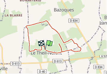
Tocht Stappen van 7,7 km beschikbaar op Normandië, Eure, Le Theil-Nolent. Deze tocht wordt voorgesteld door werth.
Plaatsbepaling
Land:
France
Regio :
Normandië
Departement/Provincie :
Eure
Gemeente :
Le Theil-Nolent
Locatie:
Unknown
Vertrek:(Dec)
Vertrek:(UTM)
320445 ; 5447599 (31U) N.
Opmerkingen