


warnant 3

PatrickVANDEPAR
Gebruiker
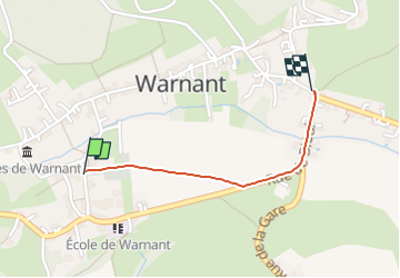

Lengte
837 m

Max. hoogte
143 m

Positief hoogteverschil
4 m
Km-Effort
960 m

Min. hoogte
114 m

Negatief hoogteverschil
25 m
Boucle
Neen
Datum van aanmaak :
2023-01-24 09:06:10.742
Laatste wijziging :
2023-01-24 09:16:51.451
10m
Moeilijkheid : Gemakkelijk

Gratisgps-wandelapplicatie
 SityTrail
IGN / Geografische instituten
SityTrail Plus
De wereld gaat voor u open
Over ons
Tocht Stappen van 837 m beschikbaar op Wallonië, Namen, Anhée. Deze tocht wordt voorgesteld door PatrickVANDEPAR.
Plaatsbepaling
Land:
Belgium
Regio :
Wallonië
Departement/Provincie :
Namen
Gemeente :
Anhée
Locatie:
Unknown
Vertrek:(Dec)
Vertrek:(UTM)
630437 ; 5575991 (31U) N.
Opmerkingen