


Jog VLH 4,3km 25’

thomarche
Gebruiker

Lengte
4,4 km

Max. hoogte
196 m

Positief hoogteverschil
42 m
Km-Effort
5 km

Min. hoogte
165 m

Negatief hoogteverschil
42 m
Boucle
Ja
Datum van aanmaak :
2023-01-28 08:57:23.0
Laatste wijziging :
2023-01-28 09:25:01.129
27m
Moeilijkheid : Onbekend

Gratisgps-wandelapplicatie
 SityTrail
IGN / Geografische instituten
SityTrail Plus
De wereld gaat voor u open
Over ons
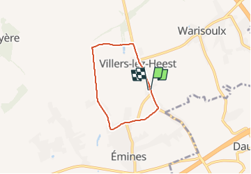
Tocht Lopen van 4,4 km beschikbaar op Wallonië, Namen, La Bruyère. Deze tocht wordt voorgesteld door thomarche.
Beschrijving
Marché vite 100m
Plaatsbepaling
Land:
Belgium
Regio :
Wallonië
Departement/Provincie :
Namen
Gemeente :
La Bruyère
Locatie:
Unknown
Vertrek:(Dec)
Vertrek:(UTM)
631029 ; 5598668 (31U) N.
Opmerkingen