


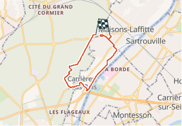
Boucle forêt St Germain - chât. Val - retour bord de Seine

sebastienu
Gebruiker

Lengte
10,1 km

Max. hoogte
83 m

Positief hoogteverschil
100 m
Km-Effort
11,5 km

Min. hoogte
18 m

Negatief hoogteverschil
111 m
Boucle
Neen
Datum van aanmaak :
2023-02-19 09:11:49.017
Laatste wijziging :
2023-02-19 11:46:41.655
2h34
Moeilijkheid : Gemakkelijk

Gratisgps-wandelapplicatie
 SityTrail
IGN / Geografische instituten
SityTrail Plus
De wereld gaat voor u open
Over ons
Tocht Stappen van 10,1 km beschikbaar op Île-de-France, Yvelines, Saint-Germain-en-Laye. Deze tocht wordt voorgesteld door sebastienu.
Beschrijving
2h30 à 4,5 km/h
Plaatsbepaling
Land:
France
Regio :
Île-de-France
Departement/Provincie :
Yvelines
Gemeente :
Saint-Germain-en-Laye
Locatie:
Saint-Germain-en-Laye
Vertrek:(Dec)
Vertrek:(UTM)
435907 ; 5421533 (31U) N.
Opmerkingen