


2023-02-24_09h14m57_Gour de la sompe Circuit à partir de Lagorce

Linerou
Gebruiker
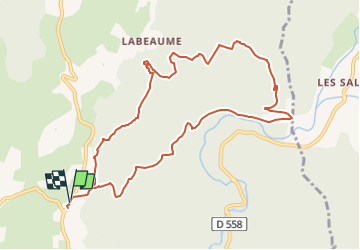

Lengte
11 km

Max. hoogte
300 m

Positief hoogteverschil
303 m
Km-Effort
15,1 km

Min. hoogte
163 m

Negatief hoogteverschil
303 m
Boucle
Ja
Datum van aanmaak :
2023-02-24 08:14:58.037
Laatste wijziging :
2023-02-27 13:15:25.705
3h25
Moeilijkheid : Medium

Gratisgps-wandelapplicatie
 SityTrail
IGN / Geografische instituten
SityTrail Plus
De wereld gaat voor u open
Over ons
Tocht Stappen van 11 km beschikbaar op Auvergne-Rhône-Alpes, Ardèche, Lagorce. Deze tocht wordt voorgesteld door Linerou.
Plaatsbepaling
Land:
France
Regio :
Auvergne-Rhône-Alpes
Departement/Provincie :
Ardèche
Gemeente :
Lagorce
Locatie:
Unknown
Vertrek:(Dec)
Vertrek:(UTM)
612639 ; 4923771 (31T) N.
Opmerkingen