


Les Avins ac 1

colsonandre
Gebruiker
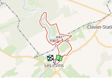

Lengte
6,9 km

Max. hoogte
249 m

Positief hoogteverschil
126 m
Km-Effort
8,6 km

Min. hoogte
199 m

Negatief hoogteverschil
124 m
Boucle
Ja
Datum van aanmaak :
2023-03-08 17:30:13.688
Laatste wijziging :
2023-03-08 17:31:27.319
1h57
Moeilijkheid : Medium

Gratisgps-wandelapplicatie
 SityTrail
IGN / Geografische instituten
SityTrail Plus
De wereld gaat voor u open
Over ons
Tocht Stappen van 6,9 km beschikbaar op Wallonië, Luik, Clavier. Deze tocht wordt voorgesteld door colsonandre.
Plaatsbepaling
Land:
Belgium
Regio :
Wallonië
Departement/Provincie :
Luik
Gemeente :
Clavier
Locatie:
Unknown
Vertrek:(Dec)
Vertrek:(UTM)
663391 ; 5587357 (31U) N.
Opmerkingen