


2023-03-08_20h27m09_1678303622294_J Ronquerolle bois la tour du Lay

avdem
Gebruiker
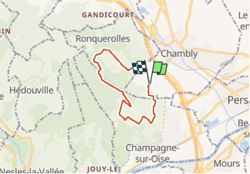

Lengte
10,1 km

Max. hoogte
174 m

Positief hoogteverschil
153 m
Km-Effort
12,2 km

Min. hoogte
53 m

Negatief hoogteverschil
156 m
Boucle
Ja
Datum van aanmaak :
2023-03-08 19:27:11.017
Laatste wijziging :
2023-03-08 19:27:13.812

Gratisgps-wandelapplicatie
 SityTrail
IGN / Geografische instituten
SityTrail Plus
De wereld gaat voor u open
Over ons
Tocht van 10,1 km beschikbaar op Hauts-de-France, Oise, Chambly. Deze tocht wordt voorgesteld door avdem.
Plaatsbepaling
Land:
France
Regio :
Hauts-de-France
Departement/Provincie :
Oise
Gemeente :
Chambly
Locatie:
Unknown
Vertrek:(Dec)
Vertrek:(UTM)
443870 ; 5445117 (31U) N.
Opmerkingen