


REC Blénod

PhilippeC54
Gebruiker

Lengte
21 km

Max. hoogte
366 m

Positief hoogteverschil
392 m
Km-Effort
27 km

Min. hoogte
181 m

Negatief hoogteverschil
392 m
Boucle
Ja
Datum van aanmaak :
2023-03-22 13:02:14.825
Laatste wijziging :
2023-03-22 15:54:41.804
2h08
Moeilijkheid : Medium

Gratisgps-wandelapplicatie
 SityTrail
IGN / Geografische instituten
SityTrail Plus
De wereld gaat voor u open
Over ons
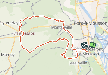
Tocht Mountainbike van 21 km beschikbaar op Grand Est, Meurthe-et-Moselle, Blénod-lès-Pont-à-Mousson. Deze tocht wordt voorgesteld door PhilippeC54.
Plaatsbepaling
Land:
France
Regio :
Grand Est
Departement/Provincie :
Meurthe-et-Moselle
Gemeente :
Blénod-lès-Pont-à-Mousson
Locatie:
Unknown
Vertrek:(Dec)
Vertrek:(UTM)
283918 ; 5418417 (32U) N.
Opmerkingen