


Luzarches_Hameaux et Lavoirs_trace_9,2 km

Pousscailleux
Gebruiker
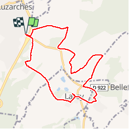

Lengte
9,2 km

Max. hoogte
104 m

Positief hoogteverschil
120 m
Km-Effort
10,8 km

Min. hoogte
50 m

Negatief hoogteverschil
120 m
Boucle
Ja
Datum van aanmaak :
2014-12-10 00:00:00.0
Laatste wijziging :
2014-12-10 00:00:00.0
2h40
Moeilijkheid : Onbekend

Gratisgps-wandelapplicatie
 SityTrail
IGN / Geografische instituten
SityTrail Plus
De wereld gaat voor u open
Over ons
Tocht Stappen van 9,2 km beschikbaar op Île-de-France, Val-d'Oise, Luzarches. Deze tocht wordt voorgesteld door Pousscailleux.
Beschrijving
Départ du parking de l'église et du cimetière de Luzarches
Foto's

Plaatsbepaling
Land:
France
Regio :
Île-de-France
Departement/Provincie :
Val-d'Oise
Gemeente :
Luzarches
Locatie:
Unknown
Vertrek:(Dec)
Vertrek:(UTM)
458331 ; 5440007 (31U) N.
Opmerkingen