


Marche Nordique

COGLAIS3
Gebruiker
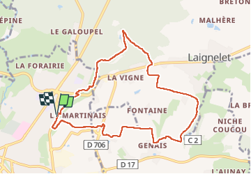

Lengte
9,2 km

Max. hoogte
188 m

Positief hoogteverschil
183 m
Km-Effort
11,6 km

Min. hoogte
111 m

Negatief hoogteverschil
183 m
Boucle
Ja
Datum van aanmaak :
2023-03-30 07:11:11.176
Laatste wijziging :
2023-03-30 10:20:43.416
2h09
Moeilijkheid : Heel gemakkelijk

Gratisgps-wandelapplicatie
 SityTrail
IGN / Geografische instituten
SityTrail Plus
De wereld gaat voor u open
Over ons
Tocht Noords wandelen van 9,2 km beschikbaar op Bretagne, Ille-et-Vilaine, Fougères. Deze tocht wordt voorgesteld door COGLAIS3.
Beschrijving
Grolay niche coucou 9,2km
Plaatsbepaling
Land:
France
Regio :
Bretagne
Departement/Provincie :
Ille-et-Vilaine
Gemeente :
Fougères
Locatie:
Unknown
Vertrek:(Dec)
Vertrek:(UTM)
634416 ; 5358098 (30U) N.
Opmerkingen