


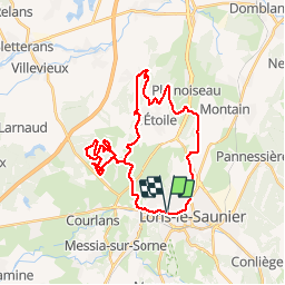
20141101 Vtt Terrain de jeu de Patrice + L'Etoile

alexbnmr
Gebruiker

Lengte
33 km

Max. hoogte
433 m

Positief hoogteverschil
799 m
Km-Effort
44 km

Min. hoogte
227 m

Negatief hoogteverschil
798 m
Boucle
Ja
Datum van aanmaak :
2014-12-10 00:00:00.0
Laatste wijziging :
2014-12-10 00:00:00.0
3h05
Moeilijkheid : Moeilijk

Gratisgps-wandelapplicatie
 SityTrail
IGN / Geografische instituten
SityTrail Plus
De wereld gaat voor u open
Over ons
Tocht Mountainbike van 33 km beschikbaar op Bourgondië-Franche-Comté, Jura, Lons-le-Saunier. Deze tocht wordt voorgesteld door alexbnmr.
Plaatsbepaling
Land:
France
Regio :
Bourgondië-Franche-Comté
Departement/Provincie :
Jura
Gemeente :
Lons-le-Saunier
Locatie:
Unknown
Vertrek:(Dec)
Vertrek:(UTM)
694537 ; 5172298 (31T) N.
Opmerkingen