


St Marc bouclette sympa

thomarche
Gebruiker
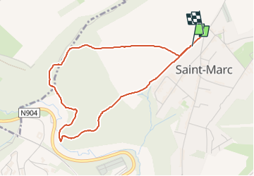

Lengte
3,9 km

Max. hoogte
186 m

Positief hoogteverschil
101 m
Km-Effort
5,3 km

Min. hoogte
113 m

Negatief hoogteverschil
100 m
Boucle
Ja
Datum van aanmaak :
2023-04-08 15:06:44.0
Laatste wijziging :
2023-04-08 15:51:54.111
44m
Moeilijkheid : Gemakkelijk

Gratisgps-wandelapplicatie
 SityTrail
IGN / Geografische instituten
SityTrail Plus
De wereld gaat voor u open
Over ons
Tocht Stappen van 3,9 km beschikbaar op Wallonië, Namen, Namen. Deze tocht wordt voorgesteld door thomarche.
Beschrijving
Chemins
Plaatsbepaling
Land:
Belgium
Regio :
Wallonië
Departement/Provincie :
Namen
Gemeente :
Namen
Locatie:
Unknown
Vertrek:(Dec)
Vertrek:(UTM)
630960 ; 5595184 (31U) N.
Opmerkingen