


19 chevreuils et 1 faisant

theo89
Gebruiker
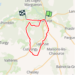

Lengte
22 km

Max. hoogte
221 m

Positief hoogteverschil
244 m
Km-Effort
26 km

Min. hoogte
146 m

Negatief hoogteverschil
243 m
Boucle
Neen
Datum van aanmaak :
2014-12-10 00:00:00.0
Laatste wijziging :
2014-12-10 00:00:00.0
3h31
Moeilijkheid : Onbekend

Gratisgps-wandelapplicatie
 SityTrail
IGN / Geografische instituten
SityTrail Plus
De wereld gaat voor u open
Over ons
Tocht Stappen van 22 km beschikbaar op Grand Est, Aube, Chaource. Deze tocht wordt voorgesteld door theo89.
Plaatsbepaling
Land:
France
Regio :
Grand Est
Departement/Provincie :
Aube
Gemeente :
Chaource
Locatie:
Unknown
Vertrek:(Dec)
Vertrek:(UTM)
584751 ; 5323403 (31U) N.
Opmerkingen