


sancy2

Titinechris
Gebruiker
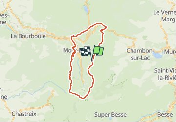

Lengte
26 km

Max. hoogte
1862 m

Positief hoogteverschil
1492 m
Km-Effort
46 km

Min. hoogte
996 m

Negatief hoogteverschil
1484 m
Boucle
Ja
Datum van aanmaak :
2023-04-21 08:34:36.624
Laatste wijziging :
2023-04-21 08:35:36.116
0m
Moeilijkheid : Medium

Gratisgps-wandelapplicatie
 SityTrail
IGN / Geografische instituten
SityTrail Plus
De wereld gaat voor u open
Over ons
Tocht Trail van 26 km beschikbaar op Auvergne-Rhône-Alpes, Puy-de-Dôme, Mont-Dore. Deze tocht wordt voorgesteld door Titinechris.
Plaatsbepaling
Land:
France
Regio :
Auvergne-Rhône-Alpes
Departement/Provincie :
Puy-de-Dôme
Gemeente :
Mont-Dore
Locatie:
Unknown
Vertrek:(Dec)
Vertrek:(UTM)
486721 ; 5045561 (31T) N.
Opmerkingen