


ardoissiere Deville

Tommy Eric
Gebruiker
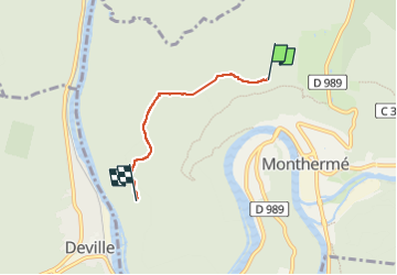

Lengte
2,9 km

Max. hoogte
349 m

Positief hoogteverschil
32 m
Km-Effort
3,6 km

Min. hoogte
232 m

Negatief hoogteverschil
121 m
Boucle
Neen
Datum van aanmaak :
2023-04-26 12:17:32.489
Laatste wijziging :
2023-04-26 13:04:53.818
38m
Moeilijkheid : Gemakkelijk

Gratisgps-wandelapplicatie
 SityTrail
IGN / Geografische instituten
SityTrail Plus
De wereld gaat voor u open
Over ons
Tocht Stappen van 2,9 km beschikbaar op Grand Est, Ardennes, Monthermé. Deze tocht wordt voorgesteld door Tommy Eric.
Plaatsbepaling
Land:
France
Regio :
Grand Est
Departement/Provincie :
Ardennes
Gemeente :
Monthermé
Locatie:
Unknown
Vertrek:(Dec)
Vertrek:(UTM)
624506 ; 5528143 (31U) N.
Opmerkingen