


Sortie CTM du 23-11

PhilippeC54
Gebruiker
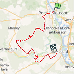

Lengte
26 km

Max. hoogte
340 m

Positief hoogteverschil
476 m
Km-Effort
32 km

Min. hoogte
178 m

Negatief hoogteverschil
450 m
Boucle
Neen
Datum van aanmaak :
2014-12-10 00:00:00.0
Laatste wijziging :
2014-12-10 00:00:00.0
2h05
Moeilijkheid : Gemakkelijk

Gratisgps-wandelapplicatie
 SityTrail
IGN / Geografische instituten
SityTrail Plus
De wereld gaat voor u open
Over ons
Tocht Mountainbike van 26 km beschikbaar op Grand Est, Meurthe-et-Moselle, Pont-à-Mousson. Deze tocht wordt voorgesteld door PhilippeC54.
Beschrijving
PAM- rue des Tilleuls, Dieulouard
Possibilité de raccourcir en prenant la route de Dieulouard à Griscourt.
Plaatsbepaling
Land:
France
Regio :
Grand Est
Departement/Provincie :
Meurthe-et-Moselle
Gemeente :
Pont-à-Mousson
Locatie:
Unknown
Vertrek:(Dec)
Vertrek:(UTM)
284254 ; 5420925 (32U) N.
Opmerkingen