


Dune la slack

CBen
Gebruiker
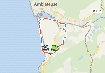

Lengte
5 km

Max. hoogte
30 m

Positief hoogteverschil
44 m
Km-Effort
5,6 km

Min. hoogte
0 m

Negatief hoogteverschil
46 m
Boucle
Ja
Datum van aanmaak :
2023-04-30 08:51:28.235
Laatste wijziging :
2023-04-30 10:45:56.203
1h54
Moeilijkheid : Gemakkelijk

Gratisgps-wandelapplicatie
 SityTrail
IGN / Geografische instituten
SityTrail Plus
De wereld gaat voor u open
Over ons
Tocht Stappen van 5 km beschikbaar op Hauts-de-France, Pas-de-Calais, Wimereux. Deze tocht wordt voorgesteld door CBen.
Plaatsbepaling
Land:
France
Regio :
Hauts-de-France
Departement/Provincie :
Pas-de-Calais
Gemeente :
Wimereux
Locatie:
Unknown
Vertrek:(Dec)
Vertrek:(UTM)
402041 ; 5627515 (31U) N.
Opmerkingen