


la peste de Daniel

Coryphene
Gebruiker

Lengte
13,4 km

Max. hoogte
621 m

Positief hoogteverschil
460 m
Km-Effort
19,4 km

Min. hoogte
175 m

Negatief hoogteverschil
422 m
Boucle
Neen
Datum van aanmaak :
2023-04-30 07:23:33.139
Laatste wijziging :
2023-04-30 13:30:00.158
3h58
Moeilijkheid : Medium

Gratisgps-wandelapplicatie
 SityTrail
IGN / Geografische instituten
SityTrail Plus
De wereld gaat voor u open
Over ons
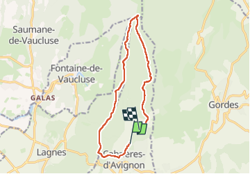
Tocht Stappen van 13,4 km beschikbaar op Provence-Alpes-Côte d'Azur, Vaucluse, Cabrières-d'Avignon. Deze tocht wordt voorgesteld door Coryphene.
Plaatsbepaling
Land:
France
Regio :
Provence-Alpes-Côte d'Azur
Departement/Provincie :
Vaucluse
Gemeente :
Cabrières-d'Avignon
Locatie:
Unknown
Vertrek:(Dec)
Vertrek:(UTM)
672989 ; 4862698 (31T) N.
Opmerkingen