Tocht  Le Hom - 2023-05-10_00h24m47_Cirkwi-Les_deux_chapelles - Photo

2023-05-10_00h24m47_Cirkwi-Les_deux_chapelles

 UDGI54
UDGI54

Gebruiker

© OpenStreetMap contributors
Lengte
Lengte
21 km
Max. hoogte
Max. hoogte
218 m
Positief hoogteverschil
578 m
Km-Effort
Km-Effort  
29 km
Min. hoogte
Min. hoogte
23 m
Negatief hoogteverschil
580 m
Boucle
Boucle
Ja
Datum van aanmaak :
2023-05-09 22:24:47.158
Laatste wijziging :
2023-05-09 22:24:49.548

(0 Bericht)


Scan deze QR-code om de tocht te openen in de SityTrail-applicatie

Gratisgps-wandelapplicatie

Logo SityTrail SityTrail

IGN / Geografische instituten

SityTrail uit de App Store downloaden SityTrail uit Google Play downloaden

Logo SityTrail SityTrail Plus

De wereld gaat voor u open

SityTrail uit de App Store downloaden SityTrail uit Google Play downloaden SityTrail op Huawei AppGallery downloaden

Over ons

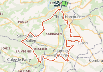
Tocht van 21 km beschikbaar op Normandië, Calvados, Le Hom. Deze tocht wordt voorgesteld door UDGI54.

Beschrijving

cette randonnée vous conduira à la Chapelle Bonne nouvelle située en rive droite de l'Orne, puis au retour à celle de Saint Joseph qui lui fait face en rive gauche. En chemin de belles perspective sur la vallée de l'Orne et ses méandres.

Hoogteprofiel

Plaatsbepaling

Land:
France
Regio :
Normandië
Departement/Provincie :
Calvados
Gemeente :
Le Hom
Locatie:
Thury-Harcourt
Vertrek:(UTM)
684219 ; 5429323 (30U) N.


Sluiten
Mijn abonnementen