


2023-05-21_18h00m05_De_Lentilleres_a_Chalancon

Linerou
Gebruiker
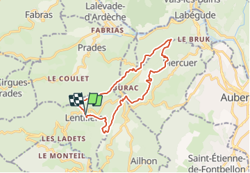

Lengte
14,2 km

Max. hoogte
592 m

Positief hoogteverschil
434 m
Km-Effort
20 km

Min. hoogte
421 m

Negatief hoogteverschil
437 m
Boucle
Ja
Datum van aanmaak :
2023-05-21 16:00:05.676
Laatste wijziging :
2023-12-31 10:29:28.869
4h32
Moeilijkheid : Zeer moeilijk

Gratisgps-wandelapplicatie
 SityTrail
IGN / Geografische instituten
SityTrail Plus
De wereld gaat voor u open
Over ons
Tocht Stappen van 14,2 km beschikbaar op Auvergne-Rhône-Alpes, Ardèche, Lentillères. Deze tocht wordt voorgesteld door Linerou.
Plaatsbepaling
Land:
France
Regio :
Auvergne-Rhône-Alpes
Departement/Provincie :
Ardèche
Gemeente :
Lentillères
Locatie:
Unknown
Vertrek:(Dec)
Vertrek:(UTM)
604186 ; 4940927 (31T) N.
Opmerkingen