


22/05/23 Lentillières Col de Farges

Linerou
Gebruiker
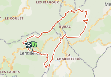

Lengte
10,4 km

Max. hoogte
590 m

Positief hoogteverschil
333 m
Km-Effort
14,9 km

Min. hoogte
421 m

Negatief hoogteverschil
346 m
Boucle
Ja
Datum van aanmaak :
2023-05-22 07:20:39.829
Laatste wijziging :
2023-05-23 13:23:05.573
2h58
Moeilijkheid : Medium

Gratisgps-wandelapplicatie
 SityTrail
IGN / Geografische instituten
SityTrail Plus
De wereld gaat voor u open
Over ons
Tocht Stappen van 10,4 km beschikbaar op Auvergne-Rhône-Alpes, Ardèche, Lentillères. Deze tocht wordt voorgesteld door Linerou.
Plaatsbepaling
Land:
France
Regio :
Auvergne-Rhône-Alpes
Departement/Provincie :
Ardèche
Gemeente :
Lentillères
Locatie:
Unknown
Vertrek:(Dec)
Vertrek:(UTM)
604191 ; 4940917 (31T) N.
Opmerkingen