


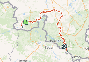
2023-05-30_10h41m09_SAT_Parcours-principal_T_2022-11-13

PatrickVANDEPAR
Gebruiker

Lengte
272 km

Max. hoogte
461 m

Positief hoogteverschil
5764 m
Km-Effort
349 km

Min. hoogte
93 m

Negatief hoogteverschil
5872 m
Boucle
Neen
Datum van aanmaak :
2023-05-30 08:41:16.353
Laatste wijziging :
2023-05-30 08:41:21.12

Gratisgps-wandelapplicatie
 SityTrail
IGN / Geografische instituten
SityTrail Plus
De wereld gaat voor u open
Over ons
Tocht van 272 km beschikbaar op Wallonië, Henegouwen, Chimay. Deze tocht wordt voorgesteld door PatrickVANDEPAR.
Plaatsbepaling
Land:
Belgium
Regio :
Wallonië
Departement/Provincie :
Henegouwen
Gemeente :
Chimay
Locatie:
Unknown
Vertrek:(Dec)
Vertrek:(UTM)
595856 ; 5537625 (31U) N.
Opmerkingen