


2019_05_22-Hatrival01

Thyves
Gebruiker
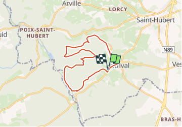

Lengte
12,6 km

Max. hoogte
480 m

Positief hoogteverschil
335 m
Km-Effort
17 km

Min. hoogte
355 m

Negatief hoogteverschil
336 m
Boucle
Ja
Datum van aanmaak :
2023-06-01 21:26:27.047
Laatste wijziging :
2023-06-01 21:35:21.528
3h52
Moeilijkheid : Gemakkelijk

Gratisgps-wandelapplicatie
 SityTrail
IGN / Geografische instituten
SityTrail Plus
De wereld gaat voor u open
Over ons
Tocht Te voet van 12,6 km beschikbaar op Wallonië, Luxemburg, Saint-Hubert. Deze tocht wordt voorgesteld door Thyves.
Beschrijving
Jolie promenade sur les plateaux d'Hatrival
Plaatsbepaling
Land:
Belgium
Regio :
Wallonië
Departement/Provincie :
Luxemburg
Gemeente :
Saint-Hubert
Locatie:
Unknown
Vertrek:(Dec)
Vertrek:(UTM)
667793 ; 5541616 (31U) N.
Opmerkingen