


Rando Christian P. Fontainebleau 20 km

jeanmarcMasson
Gebruiker GUIDE
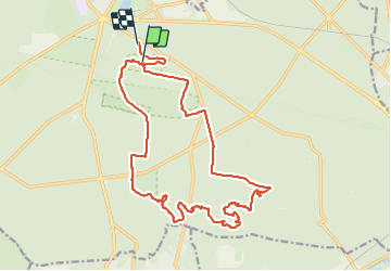

Lengte
20 km

Max. hoogte
143 m

Positief hoogteverschil
372 m
Km-Effort
25 km

Min. hoogte
83 m

Negatief hoogteverschil
400 m
Boucle
Neen
Datum van aanmaak :
2023-06-07 08:06:36.493
Laatste wijziging :
2023-06-07 14:49:47.636
5h00
Moeilijkheid : Zeer moeilijk

Gratisgps-wandelapplicatie
 SityTrail
IGN / Geografische instituten
SityTrail Plus
De wereld gaat voor u open
Over ons
Tocht Stappen van 20 km beschikbaar op Île-de-France, Seine-et-Marne, Fontainebleau. Deze tocht wordt voorgesteld door jeanmarcMasson.
Plaatsbepaling
Land:
France
Regio :
Île-de-France
Departement/Provincie :
Seine-et-Marne
Gemeente :
Fontainebleau
Locatie:
Unknown
Vertrek:(Dec)
Vertrek:(UTM)
478159 ; 5359480 (31U) N.
Opmerkingen