


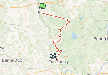
J2.1 - Saint Maurice - Commercy

Gauthier B
Gebruiker

Lengte
78 km

Max. hoogte
415 m

Positief hoogteverschil
1652 m
Km-Effort
99 km

Min. hoogte
192 m

Negatief hoogteverschil
1619 m
Boucle
Neen
Datum van aanmaak :
2023-06-07 15:45:22.542
Laatste wijziging :
2023-06-08 14:06:54.169
0m
Moeilijkheid : Heel gemakkelijk

Gratisgps-wandelapplicatie
 SityTrail
IGN / Geografische instituten
SityTrail Plus
De wereld gaat voor u open
Over ons
Tocht 4x4 van 78 km beschikbaar op Grand Est, Meuse, Les Monthairons. Deze tocht wordt voorgesteld door Gauthier B.
Plaatsbepaling
Land:
France
Regio :
Grand Est
Departement/Provincie :
Meuse
Gemeente :
Les Monthairons
Locatie:
Unknown
Vertrek:(Dec)
Vertrek:(UTM)
676006 ; 5437015 (31U) N.
Opmerkingen