


boucle sart eustache

vrenneson
Gebruiker
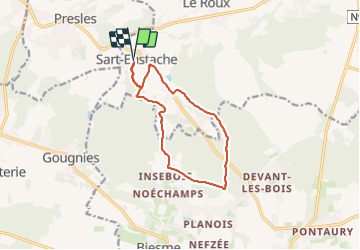

Lengte
10,7 km

Max. hoogte
273 m

Positief hoogteverschil
192 m
Km-Effort
13,3 km

Min. hoogte
143 m

Negatief hoogteverschil
191 m
Boucle
Ja
Datum van aanmaak :
2023-07-02 08:02:17.072
Laatste wijziging :
2023-07-02 10:23:52.747
2h21
Moeilijkheid : Moeilijk

Gratisgps-wandelapplicatie
 SityTrail
IGN / Geografische instituten
SityTrail Plus
De wereld gaat voor u open
Over ons
Tocht Stappen van 10,7 km beschikbaar op Wallonië, Namen, Fosses-la-Ville. Deze tocht wordt voorgesteld door vrenneson.
Beschrijving
bois, chemin, routes de campagne: très joli
Plaatsbepaling
Land:
Belgium
Regio :
Wallonië
Departement/Provincie :
Namen
Gemeente :
Fosses-la-Ville
Locatie:
Unknown
Vertrek:(Dec)
Vertrek:(UTM)
613687 ; 5581615 (31U) N.
Opmerkingen