


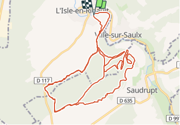
Petit circuit Vtt autour de. L’Isle

Nono55
Gebruiker

Lengte
17,3 km

Max. hoogte
246 m

Positief hoogteverschil
263 m
Km-Effort
21 km

Min. hoogte
166 m

Negatief hoogteverschil
263 m
Boucle
Ja
Datum van aanmaak :
2023-07-02 08:59:09.0
Laatste wijziging :
2023-07-02 13:06:36.454
1h16
Moeilijkheid : Gemakkelijk

Gratisgps-wandelapplicatie
 SityTrail
IGN / Geografische instituten
SityTrail Plus
De wereld gaat voor u open
Over ons
Tocht Mountainbike van 17,3 km beschikbaar op Grand Est, Meuse, L'Isle-en-Rigault. Deze tocht wordt voorgesteld door Nono55.
Beschrijving
Circuit singles
Très sympa
Plaatsbepaling
Land:
France
Regio :
Grand Est
Departement/Provincie :
Meuse
Gemeente :
L'Isle-en-Rigault
Locatie:
Unknown
Vertrek:(Dec)
Vertrek:(UTM)
650788 ; 5398012 (31U) N.
Opmerkingen