


Bonlieu4

jeanboulay
Gebruiker
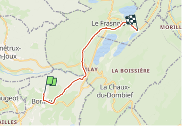

Lengte
8,7 km

Max. hoogte
822 m

Positief hoogteverschil
167 m
Km-Effort
11 km

Min. hoogte
730 m

Negatief hoogteverschil
178 m
Boucle
Neen
Datum van aanmaak :
2023-07-14 10:02:23.79
Laatste wijziging :
2023-07-14 10:02:44.472
45m
Moeilijkheid : Gemakkelijk

Gratisgps-wandelapplicatie
 SityTrail
IGN / Geografische instituten
SityTrail Plus
De wereld gaat voor u open
Over ons
Tocht Mountainbike van 8,7 km beschikbaar op Bourgondië-Franche-Comté, Jura, Bonlieu. Deze tocht wordt voorgesteld door jeanboulay.
Plaatsbepaling
Land:
France
Regio :
Bourgondië-Franche-Comté
Departement/Provincie :
Jura
Gemeente :
Bonlieu
Locatie:
Unknown
Vertrek:(Dec)
Vertrek:(UTM)
718686 ; 5165169 (31T) N.
Opmerkingen