


Redu 20/07/23

pierlan
Gebruiker
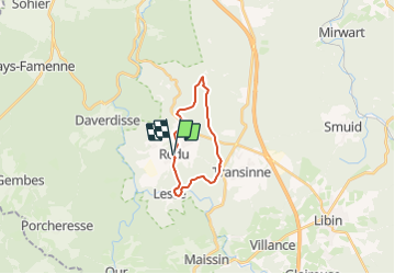

Lengte
14,4 km

Max. hoogte
453 m

Positief hoogteverschil
323 m
Km-Effort
18,7 km

Min. hoogte
287 m

Negatief hoogteverschil
318 m
Boucle
Ja
Datum van aanmaak :
2023-07-19 07:33:42.317
Laatste wijziging :
2023-07-19 07:37:16.139
4h14
Moeilijkheid : Gemakkelijk

Gratisgps-wandelapplicatie
 SityTrail
IGN / Geografische instituten
SityTrail Plus
De wereld gaat voor u open
Over ons
Tocht Te voet van 14,4 km beschikbaar op Wallonië, Luxemburg, Libin. Deze tocht wordt voorgesteld door pierlan.
Plaatsbepaling
Land:
Belgium
Regio :
Wallonië
Departement/Provincie :
Luxemburg
Gemeente :
Libin
Locatie:
Unknown
Vertrek:(Dec)
Vertrek:(UTM)
654793 ; 5541649 (31U) N.
Opmerkingen