


2023-08-26_08h28m48_SityTrail Fred-Les trois-cabanes de-Corrençon à Ernadant-Rochers-de-la-Balme -GPX

okfred26
Gebruiker

Lengte
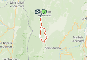
15,2 km

Max. hoogte
2011 m

Positief hoogteverschil
984 m
Km-Effort
28 km

Min. hoogte
1147 m

Negatief hoogteverschil
983 m
Boucle
Ja
Datum van aanmaak :
2023-08-26 06:28:49.757
Laatste wijziging :
2023-08-26 06:28:53.153

Gratisgps-wandelapplicatie
 SityTrail
IGN / Geografische instituten
SityTrail Plus
De wereld gaat voor u open
Over ons
Tocht van 15,2 km beschikbaar op Auvergne-Rhône-Alpes, Isère, Corrençon-en-Vercors. Deze tocht wordt voorgesteld door okfred26.
Plaatsbepaling
Land:
France
Regio :
Auvergne-Rhône-Alpes
Departement/Provincie :
Isère
Gemeente :
Corrençon-en-Vercors
Locatie:
Unknown
Vertrek:(Dec)
Vertrek:(UTM)
698319 ; 4988703 (31T) N.
Opmerkingen