


Le Poët Laval Col du Pertuis 14km

thonyc
Gebruiker GUIDE
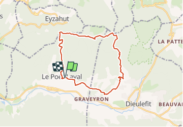

Lengte
14,3 km

Max. hoogte
929 m

Positief hoogteverschil
695 m
Km-Effort
24 km

Min. hoogte
329 m

Negatief hoogteverschil
694 m
Boucle
Ja
Datum van aanmaak :
2023-09-04 17:57:40.209
Laatste wijziging :
2023-09-04 18:05:49.849
5h21
Moeilijkheid : Zeer moeilijk

Gratisgps-wandelapplicatie
 SityTrail
IGN / Geografische instituten
SityTrail Plus
De wereld gaat voor u open
Over ons
Tocht Stappen van 14,3 km beschikbaar op Auvergne-Rhône-Alpes, Drôme, Le Poët-Laval. Deze tocht wordt voorgesteld door thonyc.
Plaatsbepaling
Land:
France
Regio :
Auvergne-Rhône-Alpes
Departement/Provincie :
Drôme
Gemeente :
Le Poët-Laval
Locatie:
Unknown
Vertrek:(Dec)
Vertrek:(UTM)
660248 ; 4933413 (31T) N.
Opmerkingen