


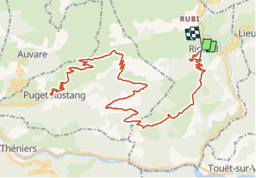
Rigaud Puget Rostang par le col de la Mairola

franquen
Gebruiker

Lengte
44 km

Max. hoogte
1475 m

Positief hoogteverschil
1559 m
Km-Effort
65 km

Min. hoogte
646 m

Negatief hoogteverschil
1745 m
Boucle
Neen
Datum van aanmaak :
2023-10-02 09:15:43.149
Laatste wijziging :
2023-10-02 16:18:38.224
4h39
Moeilijkheid : Gemakkelijk

Gratisgps-wandelapplicatie
 SityTrail
IGN / Geografische instituten
SityTrail Plus
De wereld gaat voor u open
Over ons
Tocht Mountainbike van 44 km beschikbaar op Provence-Alpes-Côte d'Azur, Alpes-Maritimes, Rigaud. Deze tocht wordt voorgesteld door franquen.
Beschrijving
rando assez longue mais pas difficile de beaux paysages notamment la descente sur Puget Rostang. Chemin très caillouteux pour atteindre le col.
Plaatsbepaling
Land:
France
Regio :
Provence-Alpes-Côte d'Azur
Departement/Provincie :
Alpes-Maritimes
Gemeente :
Rigaud
Locatie:
Unknown
Vertrek:(Dec)
Vertrek:(UTM)
338756 ; 4872238 (32T) N.
Opmerkingen