


franchimont-maché . chinru - retour

stef789
Gebruiker GUIDE
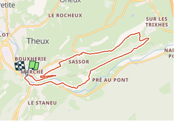

Lengte
8,8 km

Max. hoogte
306 m

Positief hoogteverschil
184 m
Km-Effort
11,2 km

Min. hoogte
169 m

Negatief hoogteverschil
186 m
Boucle
Ja
Datum van aanmaak :
2023-10-11 13:17:34.304
Laatste wijziging :
2023-10-11 15:22:43.533
2h04
Moeilijkheid : Gemakkelijk

Gratisgps-wandelapplicatie
 SityTrail
IGN / Geografische instituten
SityTrail Plus
De wereld gaat voor u open
Over ons
Tocht Stappen van 8,8 km beschikbaar op Wallonië, Luik, Theux. Deze tocht wordt voorgesteld door stef789.
Foto's


Plaatsbepaling
Land:
Belgium
Regio :
Wallonië
Departement/Provincie :
Luik
Gemeente :
Theux
Locatie:
Unknown
Vertrek:(Dec)
Vertrek:(UTM)
699875 ; 5601124 (31U) N.
Opmerkingen