


source du naye pour apr

Coryphene
Gebruiker
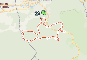

Lengte
9,3 km

Max. hoogte
478 m

Positief hoogteverschil
295 m
Km-Effort
13,2 km

Min. hoogte
276 m

Negatief hoogteverschil
284 m
Boucle
Ja
Datum van aanmaak :
2023-10-21 12:44:48.604
Laatste wijziging :
2023-11-25 08:51:28.066
2h59
Moeilijkheid : Gemakkelijk

Gratisgps-wandelapplicatie
 SityTrail
IGN / Geografische instituten
SityTrail Plus
De wereld gaat voor u open
Over ons
Tocht Te voet van 9,3 km beschikbaar op Provence-Alpes-Côte d'Azur, Var, Saint-Zacharie. Deze tocht wordt voorgesteld door Coryphene.
Plaatsbepaling
Land:
France
Regio :
Provence-Alpes-Côte d'Azur
Departement/Provincie :
Var
Gemeente :
Saint-Zacharie
Locatie:
Unknown
Vertrek:(Dec)
Vertrek:(UTM)
719375 ; 4805910 (31T) N.
Opmerkingen