![](/images/other/stat-length.png)
![Tocht Stappen Leyr - Leyr 16 190m +446m - Photo](https://media.geolcdn.com/t/1900/400/ext.pjpeg?maxdim=2&url=https%3A%2F%2Fstatic1.geolcdn.com%2Fsiteimages%2Fupload%2Ffiles%2F1553511878bg_sport_marche.png)
Leyr 16 190m +446m
DanielROLLET
Gebruiker
![Lengte](/images/other/stat-length.png)
Lengte
16,2 km
![Max. hoogte](https://static1.geolcdn.com/siteimages/upload/files/1508320355ic_sort_altitude_max_24dp.png)
Max. hoogte
414 m
![Positief hoogteverschil](https://static1.geolcdn.com/siteimages/upload/files/1508320355ic_sort_den_pos_24dp.png)
Positief hoogteverschil
446 m
![Km-Effort](/images/other/stat-length.png)
Km-Effort
22 km
![Min. hoogte](https://static1.geolcdn.com/siteimages/upload/files/1508320355ic_sort_altitude_min_24dp.png)
Min. hoogte
230 m
![Negatief hoogteverschil](https://static1.geolcdn.com/siteimages/upload/files/1508320355ic_sort_den_neg_24dp.png)
Negatief hoogteverschil
445 m
![Boucle](https://static1.geolcdn.com/siteimages/upload/files/16400158638029165_repeat_loop_refresh_sync_direction_icon.png)
Boucle
Ja
Datum van aanmaak :
2023-11-03 07:59:35.135
Laatste wijziging :
2024-01-09 19:44:39.653
![Stappen](https://static1.geolcdn.com/sitytour/trail-icons/101.png)
5h01
Moeilijkheid : Zeer moeilijk
![Scan deze QR-code om de tocht te openen in de SityTrail-applicatie](https://capi.geolives.com/qq0zvz2zws4bq2lad0pu/sitytour/trails/3857535/qr.png?size=200)
Gratisgps-wandelapplicatie
Over ons
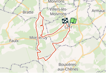
Tocht Stappen van 16,2 km beschikbaar op Grand Est, Meurthe-et-Moselle, Leyr. Deze tocht wordt voorgesteld door DanielROLLET.
Beschrijving
2023 11 03 - 9:00 à 13:00 - Avec Marie
Départ/Retour église de Leyr.
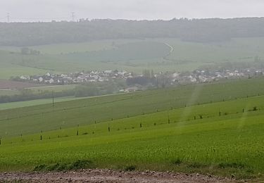
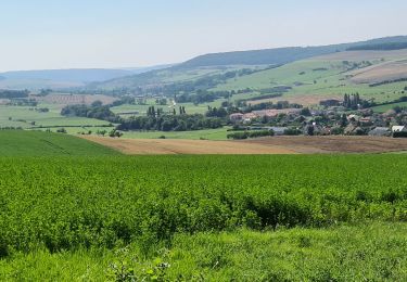
Temps frais couvert puis ensoleillé
Quelques beaux panoramas.
Plaatsbepaling
Land:
France
Regio :
Grand Est
Departement/Provincie :
Meurthe-et-Moselle
Gemeente :
Leyr
Locatie:
Unknown
Vertrek:(Dec)
Vertrek:(UTM)
299177 ; 5409089 (32U) N.
Opmerkingen
Wandeltochten in de omgeving
![Tocht Stappen Leyr - LEYR - LE PLATEAU DE LA ROCHETTE - Photo](https://media.geolcdn.com/t/375/260/ext.jpg?maxdim=2&url=https%3A%2F%2Fmedia.geolcdn.com%2Ff%2Fa23adc35-c5be-4844-8e67-6acd661e64b6.jpg)
![Stappen Stappen](https://static1.geolcdn.com/sitytour/trail-icons/101.png)
LEYR - LE PLATEAU DE LA ROCHETTE
Stappen
Gemakkelijk
Leyr,
Grand Est,
Meurthe-et-Moselle,
France
![](/images/other/stat-length.png)
12,1 km | 15,5 km-effort
5h 59min
![](https://static1.geolcdn.com/siteimages/upload/files/16400158638029165_repeat_loop_refresh_sync_direction_icon.png)
Ja
![Tocht Stappen Montenoy - MONTENOY - LE COL DE VASSUCHAMP - Photo](https://media.geolcdn.com/t/375/260/ext.jpg?maxdim=2&url=https%3A%2F%2Fmedia.geolcdn.com%2Ff%2F1b7346bf-b740-4cc9-8679-e8b003a9b130.jpg)
![Stappen Stappen](https://static1.geolcdn.com/sitytour/trail-icons/101.png)
MONTENOY - LE COL DE VASSUCHAMP
Stappen
Gemakkelijk
Montenoy,
Grand Est,
Meurthe-et-Moselle,
France
![](/images/other/stat-length.png)
12,4 km | 16,4 km-effort
4h 33min
![](https://static1.geolcdn.com/siteimages/upload/files/16400158638029165_repeat_loop_refresh_sync_direction_icon.png)
Ja
![Tocht Stappen Bouxières-aux-Chênes - tour crany 29/5/2019 - Photo](https://media.geolcdn.com/t/375/260/ext.jpg?maxdim=2&url=https%3A%2F%2Fstatic1.geolcdn.com%2Fsiteimages%2Fupload%2Ffiles%2F1553511878bg_sport_marche.png)
![Stappen Stappen](https://static1.geolcdn.com/sitytour/trail-icons/101.png)
tour crany 29/5/2019
Stappen
Heel gemakkelijk
(1)
Bouxières-aux-Chênes,
Grand Est,
Meurthe-et-Moselle,
France
![](/images/other/stat-length.png)
11,1 km | 14 km-effort
3h 42min
![](https://static1.geolcdn.com/siteimages/upload/files/16400158638029165_repeat_loop_refresh_sync_direction_icon.png)
Ja
![Tocht Te voet Faulx - Circuit L : Variant Faulx - Photo](https://media.geolcdn.com/t/375/260/ext.jpg?maxdim=2&url=https%3A%2F%2Fmedia.geolcdn.com%2Ff%2F8edc069d-a9b9-439a-9f46-3e2f5923a387.jpeg)
![Te voet Te voet](https://static1.geolcdn.com/sitytour/trail-icons/100.png)
Circuit L : Variant Faulx
Te voet
Gemakkelijk
Faulx,
Grand Est,
Meurthe-et-Moselle,
France
![](/images/other/stat-length.png)
6,3 km | 6,9 km-effort
1h 34min
![](https://static1.geolcdn.com/siteimages/upload/files/16400158638029165_repeat_loop_refresh_sync_direction_icon.png)
Neen
![Tocht Stappen Leyr - Leyr Villers les Moivrons - Photo](https://media.geolcdn.com/t/375/260/ext.jpg?maxdim=2&url=https%3A%2F%2Fmedia.geolcdn.com%2Ff%2F1040882a-d0e6-469a-943c-81b69ef5c423.jpg)
![Stappen Stappen](https://static1.geolcdn.com/sitytour/trail-icons/101.png)
Leyr Villers les Moivrons
Stappen
Medium
Leyr,
Grand Est,
Meurthe-et-Moselle,
France
![](/images/other/stat-length.png)
32 km | 42 km-effort
6h 38min
![](https://static1.geolcdn.com/siteimages/upload/files/16400158638029165_repeat_loop_refresh_sync_direction_icon.png)
Neen
![Tocht Stappen Leyr - Leyr - plateau de la Rochette - Photo](https://media.geolcdn.com/t/375/260/ext.jpg?maxdim=2&url=https%3A%2F%2Fmedia.geolcdn.com%2Ff%2Fcb8cc77e-19e0-45de-9c16-527bed2cab64.jpg)
![Stappen Stappen](https://static1.geolcdn.com/sitytour/trail-icons/101.png)
Leyr - plateau de la Rochette
Stappen
Gemakkelijk
Leyr,
Grand Est,
Meurthe-et-Moselle,
France
![](/images/other/stat-length.png)
11,8 km | 15,1 km-effort
6h 4min
![](https://static1.geolcdn.com/siteimages/upload/files/16400158638029165_repeat_loop_refresh_sync_direction_icon.png)
Ja
![Tocht Stappen Leyr - Leyr 15 000m +432m - Photo](https://media.geolcdn.com/t/375/260/ext.jpg?maxdim=2&url=https%3A%2F%2Fstatic1.geolcdn.com%2Fsiteimages%2Fupload%2Ffiles%2F1553511878bg_sport_marche.png)
![Stappen Stappen](https://static1.geolcdn.com/sitytour/trail-icons/101.png)
Leyr 15 000m +432m
Stappen
Zeer moeilijk
Leyr,
Grand Est,
Meurthe-et-Moselle,
France
![](/images/other/stat-length.png)
15 km | 21 km-effort
4h 42min
![](https://static1.geolcdn.com/siteimages/upload/files/16400158638029165_repeat_loop_refresh_sync_direction_icon.png)
Ja
![Tocht Noords wandelen Eulmont - Eulmont 9 400m +158m - Photo](https://media.geolcdn.com/t/375/260/ext.jpg?maxdim=2&url=https%3A%2F%2Fstatic1.geolcdn.com%2Fsiteimages%2Fupload%2Ffiles%2F1545311037marcheuse_200dpi.jpg)
![Noords wandelen Noords wandelen](https://static1.geolcdn.com/sitytour/trail-icons/102.png)
Eulmont 9 400m +158m
Noords wandelen
Gemakkelijk
Eulmont,
Grand Est,
Meurthe-et-Moselle,
France
![](/images/other/stat-length.png)
9,4 km | 11,5 km-effort
2h 5min
![](https://static1.geolcdn.com/siteimages/upload/files/16400158638029165_repeat_loop_refresh_sync_direction_icon.png)
Ja
![Tocht Noords wandelen Bouxières-aux-Chênes - Bouxières-aux-Chênes (nivelles) 9 200m +206m - Photo](https://media.geolcdn.com/t/375/260/ext.jpg?maxdim=2&url=https%3A%2F%2Fstatic1.geolcdn.com%2Fsiteimages%2Fupload%2Ffiles%2F1545311037marcheuse_200dpi.jpg)
![Noords wandelen Noords wandelen](https://static1.geolcdn.com/sitytour/trail-icons/102.png)
Bouxières-aux-Chênes (nivelles) 9 200m +206m
Noords wandelen
Heel gemakkelijk
Bouxières-aux-Chênes,
Grand Est,
Meurthe-et-Moselle,
France
![](/images/other/stat-length.png)
9,2 km | 11,9 km-effort
2h 10min
![](https://static1.geolcdn.com/siteimages/upload/files/16400158638029165_repeat_loop_refresh_sync_direction_icon.png)
Ja