


Chateau à diable 8.7 km

Blourouce
Gebruiker

Lengte
8,7 km

Max. hoogte
28 m

Positief hoogteverschil
44 m
Km-Effort
9,2 km

Min. hoogte
15 m

Negatief hoogteverschil
44 m
Boucle
Ja
Datum van aanmaak :
2019-01-12 16:54:32.736
Laatste wijziging :
2019-01-12 16:54:32.762
2h04
Moeilijkheid : Gemakkelijk

Gratisgps-wandelapplicatie
 SityTrail
IGN / Geografische instituten
SityTrail Plus
De wereld gaat voor u open
Over ons
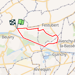
Tocht Stappen van 8,7 km beschikbaar op Hauts-de-France, Pas-de-Calais, Beuvry. Deze tocht wordt voorgesteld door Blourouce.
Plaatsbepaling
Land:
France
Regio :
Hauts-de-France
Departement/Provincie :
Pas-de-Calais
Gemeente :
Beuvry
Locatie:
Unknown
Vertrek:(Dec)
Vertrek:(UTM)
478566 ; 5598683 (31U) N.
Opmerkingen
je les fais hier et le début niquel jusqu'à que je tourne dans a droite sur un chemin et pas d'autre chemin du coup jai fais demi tours dommage 😭