


Les deux lacs

lorenzot54
Gebruiker
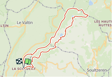

Lengte
19 km

Max. hoogte
1300 m

Positief hoogteverschil
724 m
Km-Effort
29 km

Min. hoogte
1045 m

Negatief hoogteverschil
723 m
Boucle
Ja
Datum van aanmaak :
2023-12-14 19:43:51.0
Laatste wijziging :
2023-12-14 19:43:54.574

Gratisgps-wandelapplicatie
 SityTrail
IGN / Geografische instituten
SityTrail Plus
De wereld gaat voor u open
Over ons
Tocht van 19 km beschikbaar op Grand Est, Vogezen, Le Valtin. Deze tocht wordt voorgesteld door lorenzot54.
Beschrijving
La Schlucht, Tanet, lac vert, lac des Truites retour gazon de Faing
Plaatsbepaling
Land:
France
Regio :
Grand Est
Departement/Provincie :
Vogezen
Gemeente :
Le Valtin
Locatie:
Unknown
Vertrek:(Dec)
Vertrek:(UTM)
352684 ; 5325319 (32U) N.
Opmerkingen