


st Laurent - Guillemin - Centre

stef789
Gebruiker GUIDE
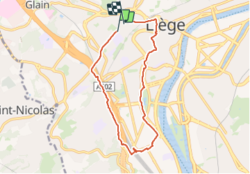

Lengte
6,7 km

Max. hoogte
120 m

Positief hoogteverschil
64 m
Km-Effort
7,6 km

Min. hoogte
63 m

Negatief hoogteverschil
84 m
Boucle
Ja
Datum van aanmaak :
2024-01-17 14:58:56.193
Laatste wijziging :
2024-01-17 16:36:34.475
1h37
Moeilijkheid : Medium

Gratisgps-wandelapplicatie
 SityTrail
IGN / Geografische instituten
SityTrail Plus
De wereld gaat voor u open
Over ons
Tocht Stappen van 6,7 km beschikbaar op Wallonië, Luik, Luik. Deze tocht wordt voorgesteld door stef789.
Foto's


Plaatsbepaling
Land:
Belgium
Regio :
Wallonië
Departement/Provincie :
Luik
Gemeente :
Luik
Locatie:
Glain
Vertrek:(Dec)
Vertrek:(UTM)
681124 ; 5613375 (31U) N.
Opmerkingen