


Thynes DEPS

thomarche
Gebruiker
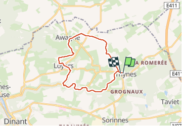

Lengte
11,7 km

Max. hoogte
292 m

Positief hoogteverschil
215 m
Km-Effort
14,5 km

Min. hoogte
154 m

Negatief hoogteverschil
213 m
Boucle
Ja
Datum van aanmaak :
2024-01-21 13:25:49.0
Laatste wijziging :
2024-01-21 16:08:56.397
2h42
Moeilijkheid : Onbekend

Gratisgps-wandelapplicatie
 SityTrail
IGN / Geografische instituten
SityTrail Plus
De wereld gaat voor u open
Over ons
Tocht Stappen van 11,7 km beschikbaar op Wallonië, Namen, Dinant. Deze tocht wordt voorgesteld door thomarche.
Beschrijving
Superbe vallée encaissée du Ruisseau du Fond de la Leffe. Puis très beaux chemins. Faite sous grand manteau de neige…
Plaatsbepaling
Land:
Belgium
Regio :
Wallonië
Departement/Provincie :
Namen
Gemeente :
Dinant
Locatie:
Unknown
Vertrek:(Dec)
Vertrek:(UTM)
641534 ; 5571656 (31U) N.
Opmerkingen