


Spa

Ban
Gebruiker
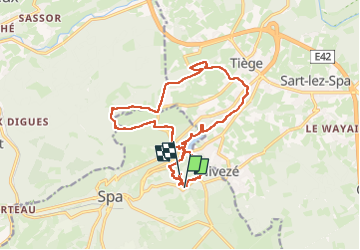

Lengte
15,8 km

Max. hoogte
379 m

Positief hoogteverschil
361 m
Km-Effort
21 km

Min. hoogte
286 m

Negatief hoogteverschil
360 m
Boucle
Neen
Datum van aanmaak :
2024-02-04 09:26:32.0
Laatste wijziging :
2024-02-04 12:37:56.352

Gratisgps-wandelapplicatie
 SityTrail
IGN / Geografische instituten
SityTrail Plus
De wereld gaat voor u open
Over ons
Tocht van 15,8 km beschikbaar op Wallonië, Luik, Spa. Deze tocht wordt voorgesteld door Ban.
Beschrijving
Bien mais boueux
Plaatsbepaling
Land:
Belgium
Regio :
Wallonië
Departement/Provincie :
Luik
Gemeente :
Spa
Locatie:
Unknown
Vertrek:(Dec)
Vertrek:(UTM)
704851 ; 5597544 (31U) N.
Opmerkingen