


adeps grandvoir

thomas1986
Gebruiker
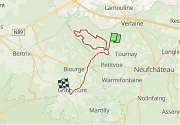

Lengte
17,5 km

Max. hoogte
481 m

Positief hoogteverschil
348 m
Km-Effort
22 km

Min. hoogte
361 m

Negatief hoogteverschil
339 m
Boucle
Neen
Datum van aanmaak :
2024-01-28 10:16:15.653
Laatste wijziging :
2024-02-04 13:36:30.13
2h30
Moeilijkheid : Heel gemakkelijk

Gratisgps-wandelapplicatie
 SityTrail
IGN / Geografische instituten
SityTrail Plus
De wereld gaat voor u open
Over ons
Tocht Stappen van 17,5 km beschikbaar op Wallonië, Luxemburg, Neufchâteau. Deze tocht wordt voorgesteld door thomas1986.
Plaatsbepaling
Land:
Belgium
Regio :
Wallonië
Departement/Provincie :
Luxemburg
Gemeente :
Neufchâteau
Locatie:
Unknown
Vertrek:(Dec)
Vertrek:(UTM)
670556 ; 5525584 (31U) N.
Opmerkingen