


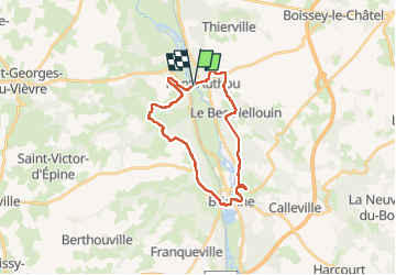
Pont Authou

RC76
Gebruiker

Lengte
24 km

Max. hoogte
144 m

Positief hoogteverschil
503 m
Km-Effort
30 km

Min. hoogte
42 m

Negatief hoogteverschil
504 m
Boucle
Ja
Datum van aanmaak :
2024-02-20 08:03:40.787
Laatste wijziging :
2024-02-20 14:58:47.413
5h54
Moeilijkheid : Zeer moeilijk

Gratisgps-wandelapplicatie
 SityTrail
IGN / Geografische instituten
SityTrail Plus
De wereld gaat voor u open
Over ons
Tocht Stappen van 24 km beschikbaar op Normandië, Eure, Pont-Authou. Deze tocht wordt voorgesteld door RC76.
Beschrijving
De Pont Authou à Pont Authou par Brionne
Plaatsbepaling
Land:
France
Regio :
Normandië
Departement/Provincie :
Eure
Gemeente :
Pont-Authou
Locatie:
Unknown
Vertrek:(Dec)
Vertrek:(UTM)
332239 ; 5456966 (31U) N.
Opmerkingen