


cherpierre cuny

Titinechris
Gebruiker
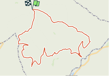

Lengte
12,1 km

Max. hoogte
519 m

Positief hoogteverschil
390 m
Km-Effort
17,3 km

Min. hoogte
312 m

Negatief hoogteverschil
390 m
Boucle
Ja
Datum van aanmaak :
2024-03-06 10:01:30.503
Laatste wijziging :
2024-03-06 10:02:17.423
0m
Moeilijkheid : Gemakkelijk

Gratisgps-wandelapplicatie
 SityTrail
IGN / Geografische instituten
SityTrail Plus
De wereld gaat voor u open
Over ons
Tocht Trail van 12,1 km beschikbaar op Grand Est, Meurthe-et-Moselle, Neufmaisons. Deze tocht wordt voorgesteld door Titinechris.
Plaatsbepaling
Land:
France
Regio :
Grand Est
Departement/Provincie :
Meurthe-et-Moselle
Gemeente :
Neufmaisons
Locatie:
Unknown
Vertrek:(Dec)
Vertrek:(UTM)
342817 ; 5368014 (32U) N.
Opmerkingen