


troglodytes 08/03/2024

Titinechris
Gebruiker
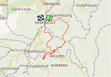

Lengte
13,7 km

Max. hoogte
462 m

Positief hoogteverschil
551 m
Km-Effort
21 km

Min. hoogte
230 m

Negatief hoogteverschil
552 m
Boucle
Ja
Datum van aanmaak :
2024-03-07 17:43:39.799
Laatste wijziging :
2024-03-07 17:43:41.773
2h30
Moeilijkheid : Medium

Gratisgps-wandelapplicatie
 SityTrail
IGN / Geografische instituten
SityTrail Plus
De wereld gaat voor u open
Over ons
Tocht Trail van 13,7 km beschikbaar op Grand Est, Moselle, Haselbourg. Deze tocht wordt voorgesteld door Titinechris.
Plaatsbepaling
Land:
France
Regio :
Grand Est
Departement/Provincie :
Moselle
Gemeente :
Haselbourg
Locatie:
Unknown
Vertrek:(Dec)
Vertrek:(UTM)
368681 ; 5396114 (32U) N.
Opmerkingen