


Louroux a/r par Doussa 17 03 24

RenaudCandottiBesson
Gebruiker
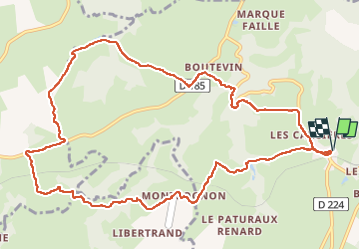

Lengte
13 km

Max. hoogte
501 m

Positief hoogteverschil
291 m
Km-Effort
16,9 km

Min. hoogte
391 m

Negatief hoogteverschil
291 m
Boucle
Ja
Datum van aanmaak :
2024-03-17 13:12:32.898
Laatste wijziging :
2024-03-17 16:43:13.216
2h55
Moeilijkheid : Moeilijk

Gratisgps-wandelapplicatie
 SityTrail
IGN / Geografische instituten
SityTrail Plus
De wereld gaat voor u open
Over ons
Tocht Stappen van 13 km beschikbaar op Auvergne-Rhône-Alpes, Allier, Louroux-de-Bouble. Deze tocht wordt voorgesteld door RenaudCandottiBesson.
Plaatsbepaling
Land:
France
Regio :
Auvergne-Rhône-Alpes
Departement/Provincie :
Allier
Gemeente :
Louroux-de-Bouble
Locatie:
Unknown
Vertrek:(Dec)
Vertrek:(UTM)
498479 ; 5119159 (31T) N.
Opmerkingen