


poullailer par chenedêt

coglais
Gebruiker
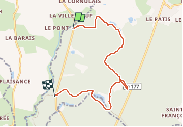

Lengte
7 km

Max. hoogte
183 m

Positief hoogteverschil
93 m
Km-Effort
8,2 km

Min. hoogte
131 m

Negatief hoogteverschil
87 m
Boucle
Neen
Datum van aanmaak :
2024-03-21 08:47:40.502
Laatste wijziging :
2024-03-21 11:45:07.3
2h04
Moeilijkheid : Heel gemakkelijk

Gratisgps-wandelapplicatie
 SityTrail
IGN / Geografische instituten
SityTrail Plus
De wereld gaat voor u open
Over ons
Tocht Noords wandelen van 7 km beschikbaar op Bretagne, Ille-et-Vilaine, Landéan. Deze tocht wordt voorgesteld door coglais.
Beschrijving
poullailer forêt de fougères
Plaatsbepaling
Land:
France
Regio :
Bretagne
Departement/Provincie :
Ille-et-Vilaine
Gemeente :
Landéan
Locatie:
Unknown
Vertrek:(Dec)
Vertrek:(UTM)
634468 ; 5363278 (30U) N.
Opmerkingen