


ADEPS Sart Lez Spa

JM Heine
Gebruiker
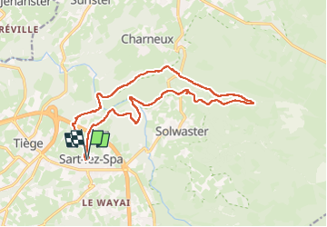

Lengte
15,6 km

Max. hoogte
477 m

Positief hoogteverschil
374 m
Km-Effort
21 km

Min. hoogte
284 m

Negatief hoogteverschil
376 m
Boucle
Ja
Datum van aanmaak :
2024-03-31 08:34:04.0
Laatste wijziging :
2024-03-31 12:15:09.162
3h39
Moeilijkheid : Gemakkelijk

Gratisgps-wandelapplicatie
 SityTrail
IGN / Geografische instituten
SityTrail Plus
De wereld gaat voor u open
Over ons
Tocht Stappen van 15,6 km beschikbaar op Wallonië, Luik, Jalhay. Deze tocht wordt voorgesteld door JM Heine.
Plaatsbepaling
Land:
Belgium
Regio :
Wallonië
Departement/Provincie :
Luik
Gemeente :
Jalhay
Locatie:
Unknown
Vertrek:(Dec)
Vertrek:(UTM)
707875 ; 5600257 (31U) N.
Opmerkingen