


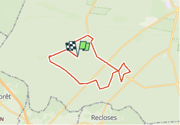
T-A53s- Gros Poisson en forêt de Fontainebleau

Jack-94
Gebruiker

Lengte
14,1 km

Max. hoogte
146 m

Positief hoogteverschil
102 m
Km-Effort
15,4 km

Min. hoogte
124 m

Negatief hoogteverschil
102 m
Boucle
Ja
Datum van aanmaak :
2024-04-01 07:38:25.598
Laatste wijziging :
2024-04-01 19:30:06.727
4h47
Moeilijkheid : Moeilijk

Gratisgps-wandelapplicatie
 SityTrail
IGN / Geografische instituten
SityTrail Plus
De wereld gaat voor u open
Over ons
Tocht Stappen van 14,1 km beschikbaar op Île-de-France, Seine-et-Marne, Fontainebleau. Deze tocht wordt voorgesteld door Jack-94.
Plaatsbepaling
Land:
France
Regio :
Île-de-France
Departement/Provincie :
Seine-et-Marne
Gemeente :
Fontainebleau
Locatie:
Unknown
Vertrek:(Dec)
Vertrek:(UTM)
472113 ; 5358087 (31U) N.
Opmerkingen