


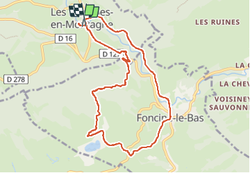
Les Planches-en-montagne en passant par Foncine-le-bas

micheldutilleul
Gebruiker

Lengte
9,7 km

Max. hoogte
892 m

Positief hoogteverschil
233 m
Km-Effort
12,8 km

Min. hoogte
717 m

Negatief hoogteverschil
232 m
Boucle
Ja
Datum van aanmaak :
2024-04-17 12:02:15.1
Laatste wijziging :
2024-04-19 11:17:07.396
2h00
Moeilijkheid : Gemakkelijk

Gratisgps-wandelapplicatie
 SityTrail
IGN / Geografische instituten
SityTrail Plus
De wereld gaat voor u open
Over ons
Tocht Stappen van 9,7 km beschikbaar op Bourgondië-Franche-Comté, Jura, Les Planches-en-Montagne. Deze tocht wordt voorgesteld door micheldutilleul.
Plaatsbepaling
Land:
France
Regio :
Bourgondië-Franche-Comté
Departement/Provincie :
Jura
Gemeente :
Les Planches-en-Montagne
Locatie:
Unknown
Vertrek:(Dec)
Vertrek:(UTM)
271110 ; 5170924 (32T) N.
Opmerkingen