


AMBRUMESNIL

juanluco76
Gebruiker
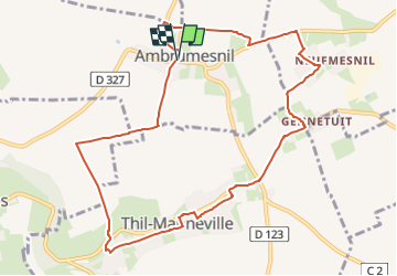

Lengte
9,9 km

Max. hoogte
93 m

Positief hoogteverschil
74 m
Km-Effort
10,9 km

Min. hoogte
59 m

Negatief hoogteverschil
74 m
Boucle
Ja
Datum van aanmaak :
2024-04-18 21:10:00.427
Laatste wijziging :
2024-04-18 21:10:42.559
2h28
Moeilijkheid : Medium

Gratisgps-wandelapplicatie
 SityTrail
IGN / Geografische instituten
SityTrail Plus
De wereld gaat voor u open
Over ons
Tocht Stappen van 9,9 km beschikbaar op Normandië, Seine-Maritime, Ambrumesnil. Deze tocht wordt voorgesteld door juanluco76.
Plaatsbepaling
Land:
France
Regio :
Normandië
Departement/Provincie :
Seine-Maritime
Gemeente :
Ambrumesnil
Locatie:
Unknown
Vertrek:(Dec)
Vertrek:(UTM)
355846 ; 5524710 (31U) N.
Opmerkingen